UNITED KINGDOM AND IRELAND (METAREA/NAVAREA I)
FRANCE and SPAIN (Metarea II/NAVAREA II)
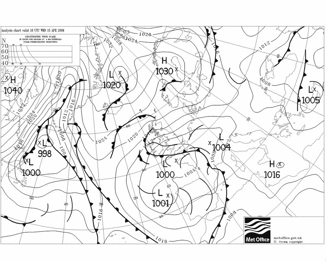
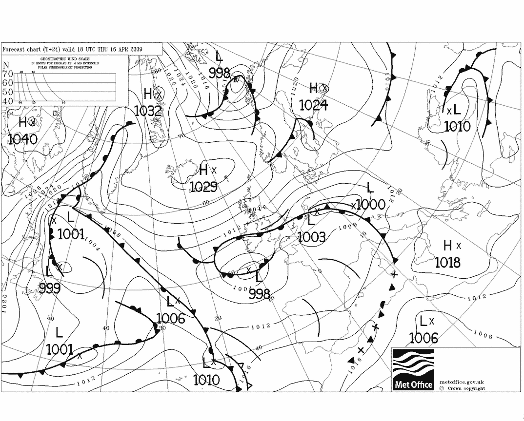
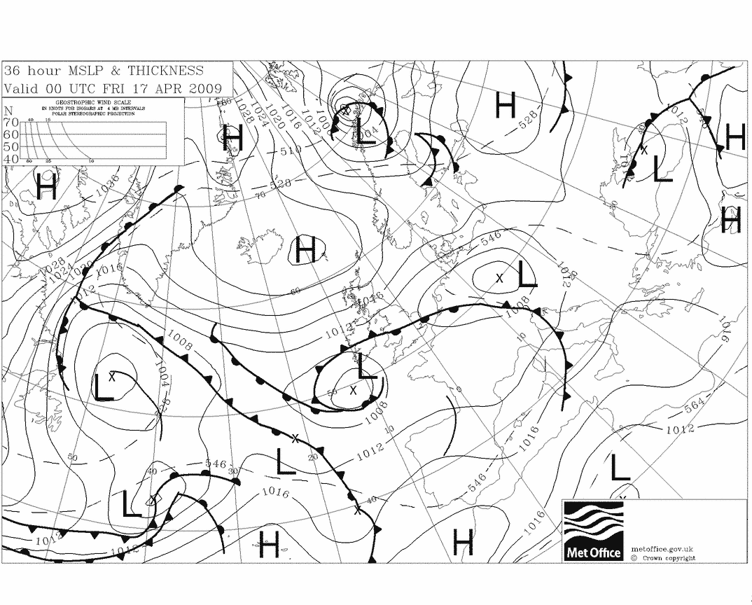
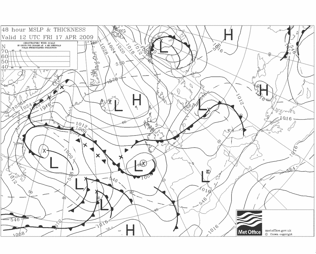
MSLP CHARTS FOR THE NORTH ATLANTIC
prepared at Bracknell UK
The above links provide
for quick downloads as the files are small, approximately 20Kbytes. For
better quality products try the following set
of links, files approx 80Kbytes:
Marine Forecasts available for other Metareas
(Click on the appropriate link. N/A indicates that there
is not a known link to the information on the Internet)
|
METAREA
|
Issuing Service
|
Forecast
|
Notes
|
|
III
|
France
|
Latest issue
|
Western areas of the Mediterranean
Issue time 0900/2100
|
|
III
|
Greece
|
N/A
|
Eastern areas of the Mediterranean
|
|
IV
|
USA
|
Latest issue
|
Issue times 0420/1020/1620/2220
|
|
V
|
Brazil
|
N/A
|
-
|
|
VI
|
Argentina
|
N/A
|
-
|
|
VII
|
South Africa
|
Latest
issue
MSLP analysis
|
Whole of Metarea VII
|
|
VIII
|
India
|
Forecasts N/A
Streamline Charts
|
Indian Ocean North of Equator
Streamline analyses/forecasts
for Indian Ocean : 925hPa level gives a good indication of surface wind
flow
|
|
VIII
|
Mauritius/Reunion
|
Latest
issue
MSLP analysis
|
Indian Ocean South of Equator
Text follows that for Metarea VII
|
|
IX
|
Pakistan
|
N/A
|
-
|
|
IX
|
Saudi Arabia
|
N/A
|
-
|
|
X
|
Australia
|
Latest issue
Click on map for area required
MSLP charts
|
Useful menu of MSLP analyses
and forecasts
|
|
XI
|
China/Hong Kong
|
Latest
|
Hong Kong Shipping areas
|
|
XII
|
USA
|
Latest
|
North Pacific E of 180°E
|
|
XIII
|
Russia
|
N/A
|
-
|
|
XIV
|
New Zealand
|
Latest issue
Click on map for area required
|
Areas
SUBTROPIC, FORTIES PACIFIC
See Australia for relevant synoptic
charts
|
|
XV
|
Chile
|
N/A
|
–
|
|
XVI
|
USA
|
Latest
|
Area to west of Peru
|
CHARTS (MEAN SEA-LEVEL PRESSURE) FOR THE OCEANIC AREAS
Courtesy NWS via
Karlsruhe University
site
Other useful links:
- Guide Marine de Météo-France - for the
online version of the Guide click
here
- NWS products available via Inmarsat SafetyNET
TM and other links to useful information, click
here
- For a comprehensive on-line NWS guide to marine products on
the Internet, click
here
- Radio-facsimile broadcasts
- The NOAA Guide to world-wide radio-fax broadcasts:
to view this publication click
here
- Quickborn/Pinneberg (DWD) radio-fax broadcast : for schedule
click here
- Quickborn/Pinneberg (DWD) radio-telex Met broadcast :
for schedule (revised 3rd April 2001) click
here
- Northwood radio-fax broadcast - schedule broadcast at
0236 and 1424
on all four frequencies: 2618.5, 4610, 8040 & 11086.5kHz
UTC. For an on-line schedule click here
Return to Main Index
Top of page
Special Note: Sources
of meteorological information on the Internet are not guaranteed
and therefore must not be relied upon. Several of the
links above are provided by Universities and they have no operational requirement
to ensure that the information is up-to-date. Also the information provided
by the National Meteorological Services via the Internet is not part of
an operational service.
If your safety is at stake you should ensure that you have the correct
equipment (NAVTEX & SafetyNET receivers) to receive warnings and forecasts
provided as part of the GMDSS. Note that many sites have copyright restrictions
and, in general, the information must not be used for commercial gain unless
permission has been obtained either from the Meteorological Service concerned
or from the provider of the information. Page prepared by Martin Stubbs
and last updated on 7th October 2001. Comments, additions and corrections
can be sent via e-mail: tempusfugit@zetnet.co.uk
CHARTS FROM VARIOUS SOURCES
Updated on 18th November 2001 - Bracknell charts available
via the UK Weather once again - please note the
disclaimer at bottom of page
UK Met Office Bracknell
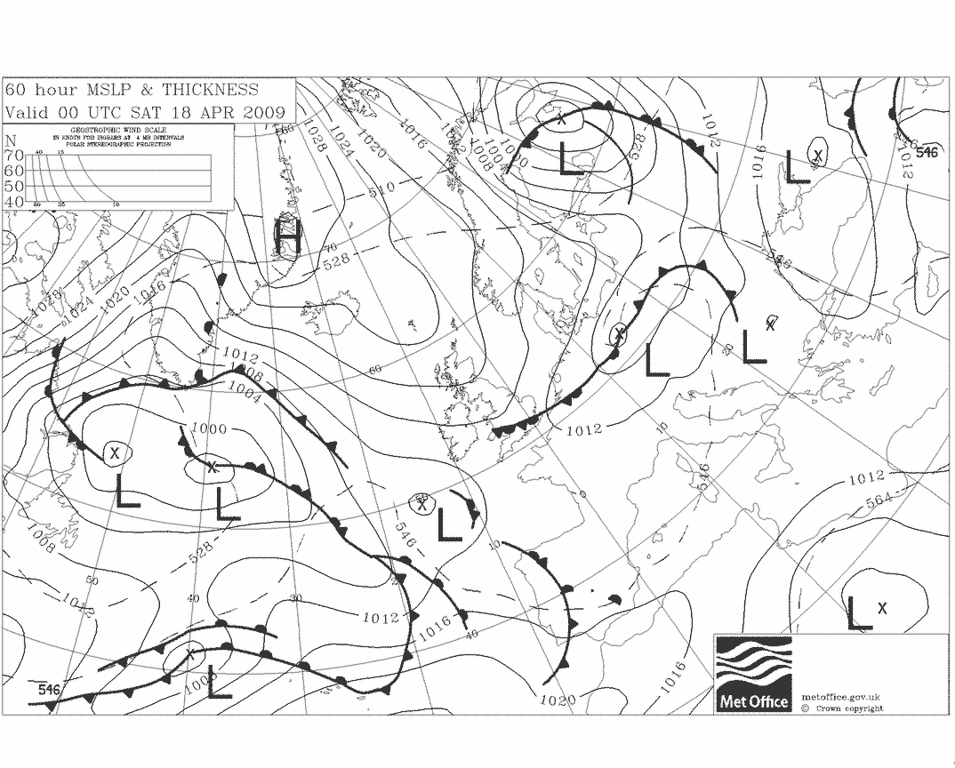
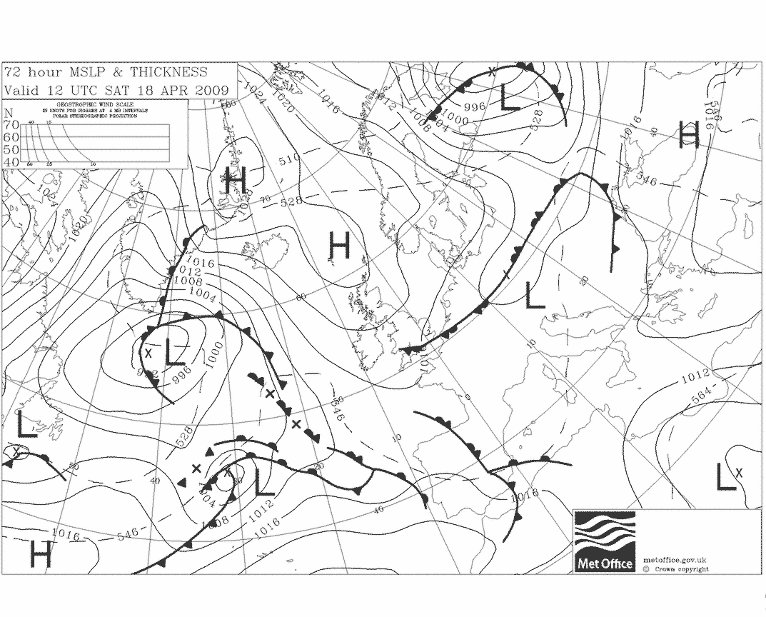
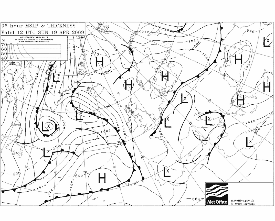
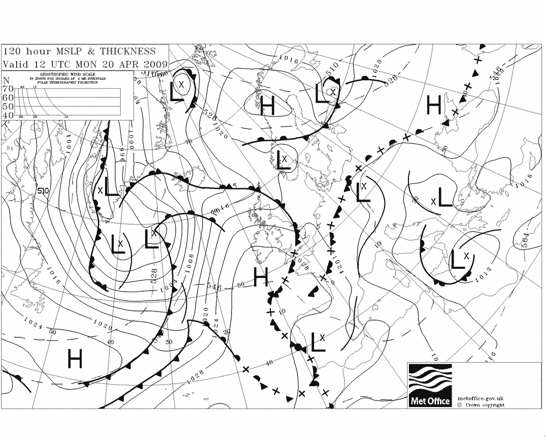
MSLP CHARTS FOR THE NORTH ATLANTIC
For quick downloads (files are approximateley 20Kbytes)
use the links below.
Output from the UK Met Office Unified Model
Wetterzentrale Site
The MSLP output includes the 500-hPa field (colour shading),
and the key 1000/500-hPa thickness isopleths (eg 510 dam, 528 dam, 546 dam,
564 dam, and 582 dam).
MSLP:
T+0
, T+12
, T+24
, T+36
, T+48
, T+60
, T+72
, T+96
, T+120
, 3-Day-Panel
,
850-hPa temperature:
T+0
, T+24
, T+48
Meteocentre Site
Two sets of charts are available, MSLP isobaric output
(4-mb spacing) plus 500-hPa contours and the key total thickness of the
1000/500-hPa layer (in the standard colours used by the Met Office (Brown
- 510 dam, Blue - 528 dam, Green - 546 dam, Red - 564 dam, Purple - 582
dam). The Models Menu page
on the site provides a wide choice of presentations. The links below are
a selection of the pages available. Products are available separately from
the last two runs of the model (based on 0000 GMT and 1200 GMT data). The
looped sequence interface allows the viewer several options including the
selection of specific frames.
MSLP, 500-hPa and the 1000/500-hPa total thickness
- Looped sequences (T+0 to T+72 in 6-hour steps):
00 GMT Run
, 12
GMT Run
- Six-panel format (T+12 to T+72 in 12-hour steps):
00 GMT Run
,
12 GMT Run
Individual frames at 6-hour intervals MSLP+500hPa+Thickness:
00 GMT run:
T+0
,
T+6
,
T+12
,
T+18
,
T+24
,
T+30
,
T+36
,
T+42
,
T+48
,
T+60
,
T+72
12 GMT run:
T+0
,
T+6
,
T+12
,
T+18
,
T+24
,
T+30
,
T+36
,
T+42
,
T+48
,
T+60
,
T+72
Institute for Geophysics and Meteorology University
of Cologne
(This site has many links to current weather - plotted
charts and links to other related products)
Current weather
index page
Deutscheur Wetterdienst (DWD)
(Analyses and model output based on the 0000 UTC run except
for the 30-hour forecast which is based on the 1800 UTC model run)
Surface Analysis for 00Z (with plotted observations) and a Surface
Prognosis for 12Z the following day
The following two charts via
the Free University of Berlin
are the only two charts available on the Internet from the DWD (updated
charts do not usually appear until after 9am UK time). Charts (see below)
other than the surface analysis for which links are available are copies
of the charts broadcast by the DWD on its
radio-facsimile
broadcast.
Surface Analysis for 00:00 UTC
T+36 Surface Prognosis VT 12:00 UTC tomorrow
The DWD disseminates additional model output and manually
adjusted prognoses for the North Atlantic area and Europe on its
radio-facsimile
broadcast. Also included on the broadcast are charts of output (out to
T+72) from the DWD Global Model, again for much of the North Atlantic and
Europe, but in a four-up presentation. The
Observatori Meteorològic de Sort
makes many of these products available on the Web in GIF format. It
is noted that only products out to T+72 are available (the T+96 prognosis
on the broadcast is only provided for the marine community within the context
of the Convention for Safety of Life at Sea and cannot be made available
to third parties). It is noted that the quality of the products depends
on reception of the radio broadcast and therefore the quality of the charts
can vary considerably from day to day.
Note that for ease of access, this server grabs
several of the products from the Observatori Meteorològic de Sort
site and zips them into two zipped files (see below).
Analyses and forecast charts (forecaster adjusted model products)
- based on 00Z data (note that the 30-hr
forecast is based on 18Z model output)
Surface
Analysis (00Z)
30-hour forecast (VT 00Z)
48-hour forecast
(VT 00Z)
72-hour forecast (VT 00Z)
Global Model output in 4-up format
H=Contour lines of geopotential height (gpdam), T=Isotherms
(°C)
P=MSL pressure (hPa) U=Relative Humidity (%)
T+12/T+24 : 500hPa
(H+T)/Surface (P)
T+36/T+48 : 500hPa (H+T)/Surface (P)
T+60/T+72 : 500hPa (H+T)/Surface (P)
T+12/T+24 : 850hPa
(T)/700hPa (U)
T+36/T+48 : 850hPa (T)/700hPa (U)
T+60/T+72 : 850hPa (T)/700hPa (U)
ECMWF model
(European Centre for Medium-range Weather Forecasting, based in United
Kingdom)
- run on 1200 GMT data only
ECMWF:
Menu to various chart displays
direct from the ECMWF, UK
Index to ECMWF charts available on the
Unisys site
Surface Pressure & 500 hPa Heights
Index
4-Panel (T+3 to T+6 days)
,
3 day
,
4 day
,
5 day
,
6 day
ECMWF charts available on the INFOMET site (Spain)
Surface Pressure & 500 hPa Heights
T+0
, 6-Panel
(T+1 to T+6 days)
850 hPa Temperatures
T+0
, 6-Panel
(T+1 to T+6 days)
NCEP (National Center for Environmental Prediction, United States)
AVN MODEL output for the European sector
AVN Run: 6-Panel presentation of Various Fields, T+12 to T+72 hours
Saving the chart and converting to a negative of the original
may make the charts easier to understand.
Charts are based on 0000 and 1200 GMT data. The links
below are to the Unisys Corp., USA)
.
Click on Info for information re the charts being accessed
Surface Pressure, 1000-500-hPa Thickness & Precipitation
(via Unisys Corp., USA)
Info.
850 hPa height, winds & temperatures
(via Unisys Corp., USA)
Info.
700 hPa Heights, Winds & Vertical Velocity
(via Unisys Corp., USA)
Info.
500 hPa Heights, Winds & Absolute Vorticity
(via Unisys Corp., USA)
Info.
300 hPa Heights & Winds
(via Unisys Corp., USA)
Info.
Integrated 850-500 hPa Relative Humidity
(via Unisys Corp., USA)
Info.
This page updated
on 18th November 2001. The links are provided 'as is' with no guarantee
that they provide the latest information. If you are sailing you should
always ensure that you access the official information provided by the various
Meteorological Services. E-mails to (no replies until early December):
tempusfugit@zetnet.co.uk.
Analyse de cartes (prévisions USAF):
http://131.54.120.150/GifImages/metsatanal.gif
prévision à 12h :
http://131.54.120.150/GifImages/synoptic12.gif
prévision à 24h :
http://131.54.120.150/GifImages/synoptic24.gif
prévision à 36h :
http://131.54.120.150/GifImages/synoptic36.gif
prévision à 48h :
http://131.54.120.150/GifImages/synoptic48.gif
prévision à 72h :
http://131.54.120.150/GifImages/synoptic72.gif
prévision à 96h :
http://131.54.120.150/GifImages/synoptic96.gif
prévision à 120h :
http://131.54.120.150/GifImages/synoptic120.gif
Analyse de cartes (prévisions BRACKNELL): (ne marche pas à
tous les coups)
http://129.13.102.93/~gmueller/pics/bracka.gif
ou
http://imkpc3.physik.uni-karlsruhe.de/wz/pics/bracka.gif
ou
prévision à 24h :
http://129.13.102.93/~gmueller/pics/brack0.gif
prévision à 48h :
http://129.13.102.93/~gmueller/pics/brack1.gif
prévision à 72h :
http://129.13.102.93/~gmueller/pics/brack2.gif
prévision à 96h :
http://129.13.102.93/~gmueller/pics/brack3.gif
prévision à 120h :
http://129.13.102.93/~gmueller/pics/brack4.gif
Météo américaine intéractive :
http://www.arl.noaa.gov/ready-bin/arlplot1.pl?metdata=AVN+191+km
Météo mondiale intéractive :
http://152.80.49.210/PUBLIC/WXMAP/GLOBAL/
Photo satellite en direct de notre région
http://www.nemoc.navy.mil/LIBRARY/AOR/NEMOC/Regional+MED/IMAGERY/METEOSAT/Naples+Visual/index.html
http://www.nemoc.navy.mil/
(This is a Department of Defense computer system)
Photo satellite en direct des caraïbes:
https://www.nlmoc.navy.mil/cgi-bin/latest.pl?sat+carib+vis
un menu assez complet...
https://www.nlmoc.navy.mil/home1.html
Autres Photos satellites (européen):
ftp://ftp.ccc.nottingham.ac.uk/pub/sat-images/
explications :
ftp://ftp.ccc.nottingham.ac.uk/pub/sat-images/README
Pour chez nous :
ftp://ftp.ccc.nottingham.ac.uk/pub/sat-images/C03.JPG
Interface graphique pour le globe :
http://www.nottingham.ac.uk/meteosat/graphif.shtml
Choisir sa vue :
http://www.fourmilab.ch/cgi-bin/uncgi/Earth
essayer 43°N 4°E 300km d'altitude...
de nuit par temps clair, on voit bien marseille, le rhône, montpellier
avignon, barcelone, madrid, la belgique hollande, l'angleterre (Londres)...
Le dernier site que j'ai trouvé en allemand : pas mal de possibilités...
http://www.wetterzentrale.de/topkarten/
vent et vague sur 144 h
http://152.80.49.210/PUBLIC/
prevision isobarique sur 5 jours SO indien SE atlanqique:
http://grads.iges.org/pix/af.slp.html
prevision môôndiales:
http://www.arl.noaa.gov/ready-bin/metgramsrc.pl?metdata=MRF+191+km
observation vent:
http://manati.wwb.noaa.gov/quikscat/
observation isobares+vent afrique du sud:
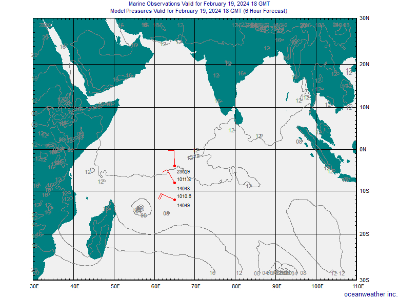
http://www.oceanweather.com/data/Indian-Northern/marineM00.gif
http://www1.meteo-reunion.com/ship1.html
Carte de surface avec courbe isobare
sur le sud ouest de l'Océan Indien -
Image satellite colorisé de l'Océan Indien -
Carte des conditions météorologiques -
Carte de la hauteur et de la direction de la houle -
Animation des prévisions de houle jusqu'à 5 jours -
Carte de température de l'eau en surface
http://www1.meteo-reunion.com/ocean_indien1.html
forum meteo ocean indien:
http://www1.meteo-reunion.com/
UM Weather: WeatherSites
Welcome to UM Weather's famous WeatherSites page.
This page provides access to over 380 North American weather sites. Look
for major improvements to this page in the coming weeks, including better
organization, the addition of a search engine, and a "What's New" section.


3si, Inc
Accu-Weather, Inc
Advanced Designs Corporation
Aerospace & Marine International
Affordable Weather Advisor
Agricultural Weather.Com
![[NEW!]](file:///F:/Mer/M%E9t%E9o/Web/new.gif)
Agricultural Weather Information Service
(AWIS)
Alden Electronics Home Page
Alert Meteorological Research
Teams
American Meteorological Society
American Weather Concepts
American Weather Enterprises
American Weather
Office
Atkins Schlacter & Assoc.,
Inc. (ASAI)
Atlantic Canada
Weather Watchers
Atmospheric Profiler Research
Facility
Automated Weather Source Homepage
Aviation Weather.Com
BBsea Ltd. Homepage
Bermuda Bio Station
for Research Satellite Imagery
Bob Hart's Offshore
and User Observation Home Page
Cable News Network
(CNN) Weather Page
California Regional Weather Server
CAPS -- Center for the Analysis
and Prediction of Storms
CAPS
-- Tornado Alley Chronicles
Central Atlantic Storm Investigators
CBF-AM Radio (Montréal,
Québec) Weather
Center for Ocean-Land-Atmosphere
Studies
Central Connecticut
State University Weather Center
CFRN-TV (Edmonton, AB) TV Weather Report
City of Vineland (NJ) Archive
College of DuPage NEXLAB
Homepage (IL)
Colorado State University
- Atmospheric Science Dept
Compu-Weather, Inc
Cooperative Institute for Meteorological
Satellite Studies
Cooperative Institute for
Research in the Atmosphere
Dakota State
University Weather
Dalhousie University Atmospheric Science
(NS)
DayWeather Homepage
EarthSat Corporation
EarthWatch Communications
Earthweek
Environment Canada - Maritimes
Environment Canada - Pacific
& Yukon Region
Environment Canada - Toronto
Environmental Research Services
Fairweather Forecasting
FEMA Tropical Weather
Watch
Fleet Numerical Meteorology and
Oceanography Center
FleetWeather, Inc.
Florida
EXPLORES! Home Page
Florida State Meteorology
Fox Weather Services
Freese-Notis Weather
Germantown/Farmersville,
Ohio Weather Archive
GOES Satellite Homepage
Global Atmospherics, Inc
Golden Gate Weather Services
Harris-Mann Weather
Henz Meteorological Services
High Plains Regional Climate Center
Hurricane Hunters
Home Page
Hurricanes 98 dot Com
Hurricane
of 1938 -- The Long Island Express
Integrated Earth Information Server
at NSF
Interactive
Marine Observations
International Weather
Satellite Imagery Center
International Weather
Watchers
Iowa
State University Atmospheric Sciences
Joint Agricultural Weather
Facility
KAUZ (Wichita Falls,
TX) 6 News First Weather
Kavouras, Inc.
KCNC-TV (Denver,
CO) StormCenter 4
KCRG-TV (Cedar
Rapids, IA) First Alert Storm Team
KFOR-TV (Oklahoma
City, OK) 4-Warn Storm Team
KGAN-TV (Cedar Rapids, IA)
Weather
KGTV-TV (San
Diego, CA) Captain Mike's Weather
KHOU-TV (Houston,
TX) Dr. Neil Frank's Forecast
KHSL-TV (Chico/Redding,
CA) Anthony's Weather Page
Kids as Global
Scientists
KIVI-TV
(Boise, ID) Weather
KJRH-TV (Tulsa, OK) Storm Team
Weather
KLAS-TV
(Las Vegas, NV) Weather
KLTV-TV (East Texas,
TX) Weather
KKTV-TV (Colorado
Springs, CO) Netline Weather
KNBC-TV (Los Angeles,
CA) Weather
KOCO-TV (Oklahoma City, OK)
Weather Center
KOIN-TV (Portland, OR) WeatherCenter
6 Homepage
KOLO-TV (Reno, NV) 5-Day Forecast
KOMO-TV (Seattle, WA) Weather
KPIX-TV (San Francisco,
CA) Live Weather Photo
KSNW-TV (Wichita, KS) Virtual
Weather Center
KSTW-TV (Seattle,
WA) Channell 11 Weather Center
KSTW-TV (Seattle, WA) WeatherDude
KTVX-TV (Salt Lake City,
UT) 4 Utah Weather
KVOA-TV (Tucson, AZ) Eyewitness
Weather
KWTV-TV (Oklahoma City,
OK) Weather Center
KXAN-TV (Austin, TX) First
Warning Weather
KXAS-TV (Fort Worth, TX)
Weather
Lighting and Storm
Imagery
Louisiana State University Earth
Scan Lab
Long Island Weather Homepage
Long
Range Weather
Lyndon State College (VT)
Marine Weather.Com
Maui Weather Today
McGill
University Weather Homepage
Meteorology
Conference Listings
Mexico Hydrometeorological
Dept
Michigan State University
Michigan Technological University
Weather
MicroForecasts Columbia River
Gorge (OR) Forecast
Midwest Climate Center
Millersville University Meteorology
MIT Center for Meteorology and Physical
Oceanography
MIT Weather
Radar Lab
Mount Washington Observatory
NASA Climate and Radiation
Research
NASA Global Change Master Directory
NASA Global Hydrology and Climate
Center
NASA Spaceflight
Meteorology Group
National Center for Atmospheric Research
National Centers for Environmental
Prediction (NCEP)
National Climatic Data
Center
National Hurricane Center
National Lightning Safety
Institute
National/Naval Ice Center
National Severe Storms Forecast
Center
National Severe Storms Laboratory
National Severe Storms
Laboratory - Boulder, CO
National Snow and Ice Data
Center
National Weather
Association
National Weather Service Home Page
National Weather Service - Arkansas/Red
River Forecast Center
National Weather Service - Aviation
Weather Center
National
Weather Service - Brownsville, TX
National Weather Service
- Burlington, VT
National
Weather Service - Corpus Christi, TX
National
Weather Service - Dodge City, KS
National Weather Service - El Paso,
TX
National Weather Service
- Grand Rapids, MI
National Weather Service - Green
Bay, WI
National Weather Service -
Greenville/Spartanburg, SC
National Weather
Service - Hastings, NE
National
Weather Service - Houston, TX
National Weather Service -
Jackson, MS
National Weather Service
- Kansas City, MO
National
Weather Service - Lake Charles, LA
National Weather
Service - Lincoln, IL
National Weather
Service - Louisville, KY
National Weather Service - Marquette,
MI
National Weather Service
- Medford, OR
National Weather Service - Memphis,
TN
National Weather Service - Melbourne,
FL
National Weather Service - Middle
Atlantic Forecast Center
National
Weather Service - Midland/Odessa, TX
National
Weather Service - Mobile, AL
National Weather Service - Newport, NC
National Weather Service - North Central River Forecast Center
National Weather Service - Northeast
River Fcst Center
National Weather
Service - North Platte, NE
National Weather Service
- Portland, OR
National Weather Service
- Pueblo, CO
National Weather Service
- Rapid City, SD
National Weather
Service - San Diego, CA
National Weather Service - State
College, PA
National Weather Service -
Tampa, FL
National Weather Service
- Wakefield, VA
National Weather Service
- Wichita, KS
National Weather
Service - Wilmington, NC
National
Weather Service - Tallahassee, FL
National Weather Service -
West Gulf River Forecast Center
National Weather Service
Forecast Office - Alaska Region
National Weather Service
Forecast Office - Albany, NY
National Weather Service
Forecast Office - Anchorage, AK
National Weather
Service Forecast Office - Birmingham, AL
National Weather Service Forecast
Office - Boise, ID
National Weather Service
Forecast Office - Boston, MA
National Weather Service Forecast
Office - Buffalo, NY
National Weather Service Forecast
Office - Charleston, WV
National Weather
Service Forecast Office - Cheyenne, WY
National Weather
Service Forecast Office - Chicago, IL
National Weather Service Forecast
Office - Cleveland, OH
National Weather Service Forecast
Office - Columbia, SC
National Weather Service
Forecast Office - Detroit, MI
National Weather Service Forecast
Office - Gray, ME
National Weather
Service Forecast Office - Honolulu, HI
National Weather Service
Forecast Office - Indianapolis, IN
National Weather Service Forecast
Office - Lubbock, TX
National Weather Service Forecast
Office - Los Angeles/Oxnard, CA
National Weather Service
Forecast Office - Minneapolis, MN
National Weather Service
Forecast Office - New York City, NY
National Weather Service
Forecast Office - Norman, OK
National Weather Service
Forecast Office - Philadelphia, PA
National Weather Service Forecast
Office - Phoenix, AZ
National Weather Service Forecast
Office - Raleigh, NC
National Weather Service Forecast
Office - Reno, NV
National
Weather Service Forecast Office - Salt Lake City, UT
National Weather Service
Forecast Office - San Francisco, CA
National Weather Service Forecast
Office - San Juan, PR
National Weather Service
Forecast Office - Seattle, WA
National Weather Service
Forecast Office - Sterling, VA
National Weather Service
Forecast Office - Topeka, KS
National
Weather Service Forecast Office - Tulsa, OK
National Weather Service
Interactive Weather Info Network
Naval Postgraduate School Meteorology
Homepage
Navy Research
Laboratory - Monterey
NCAR Information Server
New England Cable News Weather Center
New Jersey Online Farmer's
Almanac Weather
NOAA AVHRR Pathfinder Home Page
NOAA AVHRR Oceans Pathfinder
Home Page
NOAA Atlantic Oceanographic and
Meteorological Lab
NOAA Interactive
Climate Data
NOAA Climate Diagnostics Center
NOAA
Climate Prediction Center
NOAA Defense Meteorological
Satellite Program
NOAA
El Nino Homepage
NOAA Environmental Technology Lab
NOAA Forecast Systems Lab
NOAA Geostationary Satellite Browse
Server
NOAA Home Page
NOAA National Data Bouy Center
NOAA Network Information Center/NWS
Forecasts
NOAA Weather
Radio Listings
NOAA Western Regional Center
North Carolina State WWW Server
North Dakota Regional Weather Center
Northeast Regional Climate
Center
Northern Illinois
University Meteorology
Northern Maine
Weather Watch
North Saint Paul, MN Weather
Observatory
NovaLinx Corporation
Oceanweather Homepage
Ohio State Weather Server
Oregon State University Climate/Weather
Service
Pacific Air Force
Command Center Weather
Palm Beach Post Hurricane
Guide and News
PC Weather Products, Inc.
Penn State Meteorology
Pennsylvania Weather
Page
Phillips Laboratory
Atmospheric Science Division
Plainfield, VT Weather
Report
Plymouth State WWW Server (NH)
Portland (OR) Schools Meteorological
Network
Portsmouth Weather Records
Service
Potsdam, NY Temperature
Plot
Prodigy Weather Group
Purdue WXP Weather
Real-Time Environmental
Applications & Display System
Resorts Sports
Network Weather Cam
Roemer Weather
Rutgers University Meteorology
(NJ)
San Diego BayCam
San
Francisco State Univ. Meteorology
Scripps Climate Research Division
Sensor Instruments Co, Inc
SensorMetrics Homepage
South Dakota School of Mines
Weather Server
South
Dakota State University - SD Climate Information
South Florida
Water Management District Weather
Southern Regional Climate Center
Southeast Regional Climate
Center
SSEC/University of Wisconsin Weather
Information
Storm Chaser
Home Page
Storm Spotter
Glossary
Striking Images Lightning
Photography
Sunshine Weather Books
Sun-Sentinel (S.Florida)
Hurricane News
SUNY Albany Atmospheric Science
Department
SUNY Brockport Weather
Page
SUNY Oswego Meteorology
Homepage
Texas A&M Weather
Data Home Page
Texas Severe Storm Association
Texas Tech Atmospheric Science
Group
Texas Weather Instruments, Inc
Boston Meteorologist Todd Gross's
Weather/Astronomy Homepage
Tornado Project Online
Tropical Cyclone Centre
UCAR Real-Time Weather Page
UNIDATA Information Server
UNIDATA McIdas Demonsration Server
Universal Weather & Aviation,
Inc.
University of Alabama - Huntsville
Weather Homepage
University of Alaska - Fairbanks
Satellite Imagery
University of Alaska -
Fairbanks Atmospheric Science
University of California
- Davis Meteorology
University of California - Los
Angeles Atmospheric Science
University of Hawaii Satellite
Oceanography Lab
University of Hawaii Meteorology
Department
University of
Hawaii Storm Tracks
University
of Illinois CoVis Geosciences Server
University of Illinois Daily Planet
University of Kansas Atmospheric
Science
University of
Kentucky Agricultural Weather Center
University of
Maryland Meteorology (Earthcast)
University of Michigan Weather
Underground Homepage
University of Miami Sea-Surface
Temperature Maps
University of Missouri
Atmospheric Science Homepage
University of North
Carolina - Asheville Weather Web
University of North Carolina - Charlotte
Weather Server
University
of Oklahoma - College of Geosciences
University of Oregon
Current Weather Page
Universite du Quebec a
Montreal Atmospheric Science
University of Rhode Island Sea-Surface Temperature Archive
University of Utah Weather Homepage
University of
Virginia Weather Homepage
University of Washington
Weather Page
University of Wisconsin
Forecast Model Output
University
of Wisconsin - Madison Tropical Cyclone Page
University
of Wisconsin - Milwaukee Homepage
University of Wyoming Weather Web
USA Hourly
Weather Statistics
USA Today Weather
USAF 45th Weather
Squadron
USDA/CIESIN Global Environmental
Change Data Assessment and Integration Project
USGS El Nino Information
Utah Climate Center
Valparaiso University (IN) Meteorology
Web Page
VAS-DAS Satellite Imagery
Vortex Consulting
WAAY-TV (Huntsville,
AL) Weather Center
WABG-TV (Greenville,
MS) NewsWatch 6 Weather Center
WAFF-TV (Huntsville, AL) Weather
Center
WAGA-TV (Atlanta, GA) Weather Center
WBRC-TV (Birmingham,
AL) Doppler 6 Weather Center
WBOC-TV (Salisbury, MD)
Weather Center
WBTV-TV (Charlotte,
NC) Internet Weather Team
WCBS-AM-Radio
(New York City, NY) Newsradio-88 Weather
WCFT-TV (Birmingham, AL) Weather
WCIV-TV (Charleston, SC) Accu-Weather Forecast
WCVB-TV (Boston, MA) WeatherCenter 5
WDIV-TV (Detroit, MI)
WeatherWatch
WeatherBank, Inc.
The Weather Channel
WeatherData, Inc.
Weather FAQ - Hypertext version
WeatherGraphix
Homepage
WeatherLabs, Inc.
The Weather Network (Canada)
The Weather Office (Environment
Canada)
WeatherNews International
WeatherNode Server
Weather Research
Associates
Weather Research Center
Weather Routing, Inc.
WeatherSense
WeatherServ
Weather Services Corporation
Weather Science
Hotlist
Weather Scratch Meteorological
Services
Weather Site.Com
WeatherTap
The Weather Underground
Weather Watchers
Online (WWOL)
WeatherWeek
WebWeather
Western Connecticut
State University Weather Center
Western Regional Climate Center
WFRV-TV (Green
Bay, WI) EarthWatch Center5
WFSB-TV (Hartford, CT) Online
Weather
WGNX-TV (Atlanta, GA)
Weather
WHDH-TV (Boston, MA) Weather
WHNT-TV (Huntsville, AL)
Weather Center 19 Online
WHNT-TV (Huntsville, AL) Dan's
Wild Wild Weather Page
Widespread Weather Services
Wind Hot Line's Real-Time
Wind Graphs
WISC-TV (Madison,
WI) Weather
WJW-TV (Cleveland,
OH) Weather
WMC-TV
(Memphis, TN) Pinpoint Weather
WMTW-TV (Portland, ME) TV 8 Weather Center
WNEP-TV (Scranton,
PA) Weather Center
WNYT-TV (Albany, NY) First
Warning Weather
Women
in Weather
World Meteorological Organization
Worldwide Weather Insurance Agency
World-Wide
Web Virtual Library: Meteorology
WOWK-TV (Huntington, WV) Storm
Tracker 13
WOWT-TV (Omaha, NE) Precision
Forecast Center
WRAL-TV (Raleigh, NC) TV5
Weather
WRC-TV (Washington, DC) UM Weather4
WRTV-TV (Indianapolis,
IN) Storm Center 6
WSAV-TV (Savannah, GA)
Skywatch Web Weather
WSB-AM Radio (Atlanta,
GA) Weather
WSAZ-TV (Huntington, WV) PinPoint
Forecast
WSI Corporation Homepage
WSI IntelliCast Homepage
WSOC-TV
(Charlotte, NC) Weather
WTNH-TV (New Haven,
CT) Storm Team 8
WTOC-TV (Savannah, GA) Weather Home
WTVT-TV (Tampa Bay, FL) Online
Weather
WVEC-TV
(Norfolk, VA) Weather
WWBT-TV (Richmond,VA) Radar Plus
Weather
WXIN-TV (Indianapolis, IN)
Fox Weather
Zephyrus Electronics


 ©
Copyright 1995-96, UM Weather, Inc.
©
Copyright 1995-96, UM Weather, Inc.


